


Photos of Newquay - Padstow Area
and its surroundings

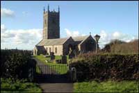
This striking little building is believed to date from the fourteenth century.
|

|

Bedruthan Steps on the North coast of Cornwall. Looking down the coast from Park Head, Diggory's Island, Queen Bess Rock, Samaritan Island, Redcove Island, Pendarves Island and Carnewas Island make up the steps of Bedruthan. Trerathick Point and beach, High Cove and Trenance Point lie beyond with Mawgan Porth and Watergate Bay (Tregurrian Beach) in the distance. |

|

|

|

|

|

|

|

|

|

Trevellas airfield, formerly RAF Perranporth stands on the cliff top. |

Fields of Corn Marigolds - Glebionis segetum - at West Pentire, Crantock, near Newquay. From late June and for most of July the fields of West Pentire are full of traditional corn field wild flowers. You can walk around the coast path at West Pentire or follow public footpaths towards Polly Joke taking you past these colourful fields. |

Crantock Beach is a popular north coast beach between Holywell Bay and Newquay. The beach is backed by tall sand dunes. The estuary of the River Gannel is located beside the beach. Crantock Beach is dog friendly all year round. Parking is available near the beach. A ferry operates between the beach and East Pentire giving easy access to Newquay. |

The River Gannel passing East Pentire to meet the sea at Crantock Beach.
|

Crantock Beach, East Pentire and Fistral Beach in the background. |

Aerial view taken from West Pentire showing Crantock beach, River Gannel, Fistral beach and Newquay. |

Crantock village is just a short distance away from its golden sandy beach. The River Gannel, a tidal river, winds its way along the far edge of the beach. In the background is East Pentire, Newquay with Fistral Beach and its other beaches. Towan Head separates Fistral Beach from Newquay's other beaches. |

St Enodoc's Church is a short walk from Daymer Bay. Rock can be seen in the background with many yachts moored in the Camel estuary. Brea Hill is an excellent viewpoint. |

|

Fishing boat on the River Camel passing St Enodoc Church. The Cornwall Coast Path follows the river on the St Enodoc side. In the foreground is part of Hawker's Cove which has a large, sandy beach at low tide. |

|

|

Fistral Beach famous for surfing, with Newquay's many beaches - Towan Beach, Tolcarne Beach, Lusty Glaze and Porth Beaches around the bay. |

Crystal clear water and golden sand at Harlyn Beach on the north coast of Cornwall between Newquay and Padstow. |

|

|

Holywell Bay has a wonderful sandy beach backed by dunes.
|

|

|

|

|

From the headland, Towan Head, in the foreground the beaches are: Harbour Beach; Towan Beach; Great Western; Tolcarne; and Lusty Glaze Beach.
|

|

The coastline around Port Isaac and towards the Camel Estuary. |

|

The Camel Trail starts at Padstow and follows the River Camel upstream to Wadebridge and beyond. The bridge across the entrance to Little Petherick Creek formerly carried trains but was converted for the use of cyclists, walkers and horse riders when the old railway line became the Camel Trail. |

On an Autumn afternoon, on an incoming tide, a fishing boat returning to port at Padstow along the River Camel.
|

|

Perranporth has one of the longest beaches in Cornwall with over two miles of golden sand. In the foreground is Ligger Point with the Penhale Sands dune system backing the beach and Reen Sands and the town of Perranporth at the end of this view. |

|

|

|

|

|

|

In late June and for most of July this amazing display of Poppies can be seen at West Pentire, near Crantock. |

|

|

The coastline around Port Isaac. Lobber Point, The Haven at Port Isaac, Port Gaverne, Castle Rock and Main Head. |

|

|

|

|

The lovely Porth Joke Beach, known locally as Polly Joke. At low tide the beach stretches away uncovering tiny coves and inlets. The stream crossing the beach is ideal for dogs. This beach is dog friendly all year round. |

|

Rock is a short ferry ride from Padstow - pedestrian ferry only. The famous sandbar - the Doom Bar can also be seen in the photograph. |

Seals between Holywell Bay and Newquay during February 2019.
|

Skylark enjoying a dust bath on the coast path near Park Head.
|

St Piran's Oratory is one of the oldest Christian buildings in Britain. For decades it has been covered by sand to conserve it. Excavations began in February 2014 and are continuing. |

|

|

|

Merope Rocks and Trevose Head Lifeboat Station, Polventon or Mother Ivey's Bay with its sandy beaches and Harlyn Bay. |

An Autumn sunset at Treyarnon Bay between Newquay and Padstow. A lovely place to watch the sun go down. |

|

|

This long, sandy beach near Newquay is only two miles from Cornwall Newquay Airport making it an ideal destination for visitors flying in to Cornwall for a short break.
|

This long sandy beach between Newquay and Padstow is popular for extreme sports. It is very close to Cornwall Newquay Airport making it ideal for visitors flying in for the weekend. |

Popular for watersports, surfing, bodyboarding, kitesurfing and even polo on the beach. |

|

Poppies, Corn Marigolds and other traditional corn field wildflowers create a riot of colour across the fields of West Pentire during the Summer. Take a summertime walk from West Pentire towards Porth Joke to enjoy this wonderful display. |
More information about Newquay - Padstow Area
View more photos in our online Cornwall Photo Gallery
|
All Photography on this website, unless stated otherwise by:
|
||
|
www.awmp.co.uk
© 2006-2026 |
www.choughmountain.design
© 2006-2026 |
|

| Newquay - Padstow Area |
|
Newquay - Padstow Area Map |
|
Newquay - Padstow Area Beaches |
|
Newquay - Padstow Area Events |
|
Newquay - Padstow Area Community Information |
|
Newquay - Padstow Area Books |
|
Newquay - Padstow Area Photos |
|
Newquay - Padstow Area Videos |
|
Newquay - Padstow Area History |


Road directions to
Newquay - Padstow Area
Using public transport
to and around Cornwall.
Plan your journeys
Buses, trains, ferries and more

Towns and villages in Cornwall and the Isles of Scilly
