


Minack Theatre at Porthcurno
Porthcurno
Cornwall Information & Accommodation Guide

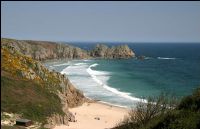
Porthcurno, with its fine beach of white sand is justly popular and extremely picturesque.
From the cliffs, the bay presents an amazing view when the sun is shining on the water and the white sand, and even during the Winter with the roughest of seas, its spectacular appearance is breathtaking.
The name of the village from the Cornish language has been variously suggested to mean Cove of Horns and Cornwall bay.
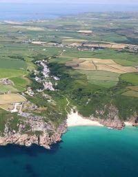
Within walking distance of the village, eastwards on the coastal path towards Treen, is a feature for those with an interest in archaeology. Treryn Dinas dates from the Iron Age and is a fine example of a cliff castle.
Walking westwards, the coastal path leads to Land's End passing Porthgwarra, Gwennap Head and the magnificent Nanjizal Bay.
General Information
The small village has a range of facilities including shops, pubs and visitor attractions. For holiday accommodation in and around Porthcurno see Porthcurno accommodation listings on this page or for accommodation throughout Cornwall visit our Cornwall Accommodation.
Nearest Tourist Information Centre is at Penzance, Station Road.
Tel: +44 (0)1736 362207
Email: penzancetic@cornwall.gov.uk

All ATMs throughout Cornwall.
If the information on this website has been useful to you please consider a donation.
This easy to use travel planner makes it simple. Just add the location in Cornwall from where you are travelling and the destination you wish to travel to and it will provide full details of times, buses, trains and ferries to get you to your destination.
Location:
Located in West Cornwall on the south coast of the Land's End peninsula between Penzance and Land's End. Easily reached from Penzance and the Land's End via the A30 trunk road.
IntoCornwall Area Map Land's End Peninsula Map
2 Fast chargers
Type 2 Connector
7kW 32 amp
Average recharge 3 - 5 hours
Free to use for customers of the The Minack.
Books online:
Click here to buy books online about Porthcurno
Find all the Dog Friendly beaches in Cornwall
More archaeological sites in Cornwall
Places of interest in or around PorthcurnoTowns, villages and other locations |
Cornish phrases and place names |
Topical phrases of the month July: 'Telling the Time'
Place Name of the Month July: Polglase
Porthcurno NEWS |

|
Porthcurno Map |
|
Porthcurno Beaches & surf report |
|
Porthcurno Events |
|
Porthcurno Community Information |
|
Porthcurno Books |
|
Porthcurno Photos |
|
Porthcurno Videos |
|
Porthcurno History |

Porthcurno
Accommodation

Businesses
in or around Porthcurno


Things to do
in this area


|
|

