


The Hurlers
Cornwall Information & Accommodation Guide

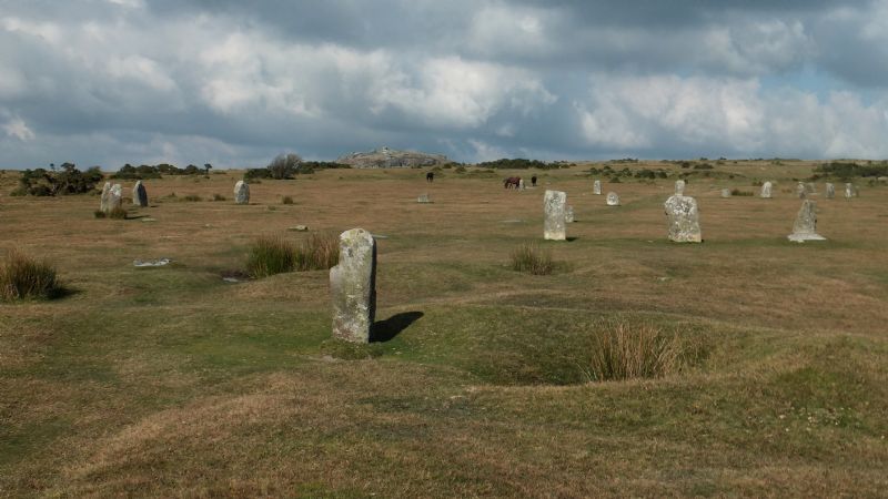
The Hurlers are a group of three late Neolithic or early Bronze Age stone circles arranged in a line and are located a short walk from Minions on the eastern side of Bodmin Moor.
This type of grouping is unique in Cornwall and The Hurlers are excellent examples of ceremonial stone circles.
Their name comes from Cornish folklore. They are traditionally thought to be the remains of men who were turned to stone for playing the game of hurling on a Sunday.
The two outlying stones, to the west of the circles, are known as the 'Pipers' (not to be confused with stones of the same name near the Merry Maidens on the Land's End peninsula), and are said to have been petrified for making music on the Sabbath.
Another folklore tale associated with the Hurlers is that it is impossible to count the number of standing stones.
The Hurlers lie on a line from SSW to NNE. Their diameters are 115 ft (35 metres), 138 ft (42 metres) and 108 ft (33 metres)
The middle circle is the largest of the three and is slightly elliptical. The two outer stone circles are circular.
The southern circle now contains nine stones but only two of the remaining stones are upright. The other seven are partially hidden by soil.
The middle circle has 14 stones out of what would have been 28.The stones show clear traces of being hammered smooth.
The northern stone circle originally contained around 30 stones but only 15 are still visible.
The two outlying standing stones, the Pipers, are 330 ft (100 metres) southwest of the middle circle and may be gateway stones to the circles, part of the processional route.
The Hurlers are a scheduled ancient monument (1981). The Pipers were included in the schedule in 1994
The Hurlers are managed by the Cornwall Heritage Trust on behalf of English Heritage.
The earliest known record of the Hurlers was made by John Norden, the historian, who visited them around 1584.
William Camden mentions them in 1586 in his Britannia.
William Borlase published the first detailed description of the site In 1754 .
The site was excavated during the 1930s by C. A. Ralegh-Radford. Two of the circles were partly restored by re-erecting some of the fallen stones an positioning marker stones in the place of stones that were missing.
Since the original excavation further investigations have been carried out including an aerial survey, a geophysical survey in 2004 and a CAU survey in 2009, which suggests that a fourth circle and two stone rows may exist here.
Alexander Thom, the Scottish engineer, has suggested that there are possibly two solar alignments of four stones with far uprights.
He suggested two stone-to-site alignments with Vega and Arcturus and two other site-to-site alignments with Arcturus. Each stellar alignment was given with tabulated declinations at a date some time in between the range of 2100 to 1500 BC.
A singer from Devon, Seth Lakeman, wrote a song about The Hurlers in 2008.
Parking is a quarter of a mile walk away.
The site is dog friendly but please keep dogs under control or on a lead as there are often ponies or other livestock in the area of the circles.
All ATMs throughout Cornwall.
If the information on this website has been useful to you please consider a donation.
This easy to use travel planner makes it simple. Just add the location in Cornwall from where you are travelling and the destination you wish to travel to and it will provide full details of times, buses, trains and ferries to get you to your destination.
Location:
Sat Nav PL14 5LE
Grid reference SX 258 714
Road directions to The Hurlers
Books online:
Click here to buy books online about The Hurlers
Find all the Dog Friendly beaches in Cornwall
More archaeological sites in Cornwall
Places of interest in or around The HurlersTowns, villages and other locations |
Cornish phrases and place names |
Topical phrases of the month July: 'Telling the Time'
Place Name of the Month July: Polglase
|
The Hurlers Map |
|
The Hurlers Events |
|
The Hurlers Community Information |
|
The Hurlers Books |
|
The Hurlers Photos |
|
The Hurlers Videos |
|
The Hurlers History |

The Hurlers
Accommodation

in or around The Hurlers


|
|

