


Hawker's Hut, Morwenstow to Duckpool
Walk
Cornwall Coast Path
Cornwall Information & Accommodation Guide

Hawker's Hut, Morwenstow to Duckpool
This walk takes you from the fascinating Hawker’s Hut, perched on the edge of cliffs at Morwenstow, past fantastic cliff scenery which has seen many shipwrecks, through a Site of Special Scientific Interest and stunning viewpoints to Duckpool, a known habitat for glow worms.
There is a car park near Morwenstow Church.
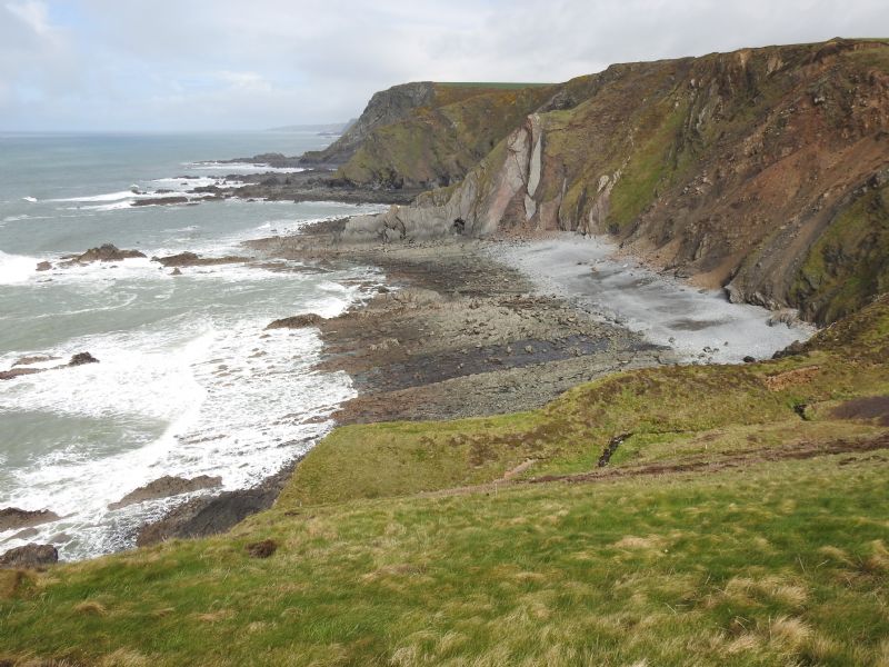
1. Walk out beside the church and follow the public footpath onto Vicarage Cliff.
The cliff here is 450 ft high. Cotton Beach lies below the cliff, named after the cargo of an 1805 ship which was wrecked here on the razor sharp rocks. The geology of this area is fascinating. This whole walk falls within an SSSI for its geology. The rocks are known as the Bude Formation. They are some of the youngest rocks of the Upper Carboniferous period, from around 280 million years ago. Of great interest are the patterns sculpted in them and the fossils which they contain of ammonoids, fish and crustaceans. Learn more about Cornwall's geology
2. After visiting Hawker’s Hut return up the steps to the coast path and walk along the path following the edge of the field.
Below you is Lucky Hole, a gap between razor sharp rocks.
3. Still hugging the cliff-top the path nears Higher Sharpnose Point.
The point is good for rock climbers as it has seven good climbs. In 1842 the Caledonia was wrecked off this point. The figurehead from the ship was salvaged and stands in the churchyard of Morwenstow Church as a memorial to those who lost their lives. It has been suggested, from various quarters, that the ship was lured onto the rocks but it is likely we shall never know the truth of what happened.
If you wish to make a brief detour from the path to walk along the ridge of Higher Sharpnose Point, take care as the path is not for the faint hearted.
4. Return to the coast path.
5. The path descends steeply to the Tidna stream.
6. Cross the footbridge across Tidna Shute.
The Tidna stream cascades over the cliff producing a waterfall
7. Pass Tidna Shute waterfall as you descend into the valley. If you wish to make a small detour there is a walk up Tidna valley through Tidna Woods.
8. Walk up a few steps to an old lookout building located near the point providing excellent panoramic views.
9. Remaining on the coast path the way is level for about half a mile (1 km)
Greenaway Beach is below you, a rocky beach with grey sand.
10. Continue along the path crossing two footbridges and follow the path uphill to Oldwalls.
It has been suggested that Oldwalls is possibly the site of a Roman signal station.
11. Follow the path down to a kissing gate then upwards for a while before ascending to a footbridge. You will soon be above Caunter Beach.
12. A spring rises above Caunter Beach. The beach is of geological interest - a wave-cut platform. The beach is of shingle and rocks with grey sand and a little yellow sand at low water. You cannot access this beach from the coast path here. On foot, the beach can only be accessed from Stanbury Mouth at low tide, involving a scramble over rocks and rock pools. The beach is dog friendly. Do not stay long at Caunter Beach as you need to be able to get back to Stanbury Mouth before you get cut off by the tide.
13. The path soon arrives at Hippa Rock.
Hippa Rock is a rocky headland popular with rock climbers as it has a number of good climbs.
14. The coast path descends steeply towards Stanbury Mouth. Above the beach cross the footbridge over the stream.
After heavy rainfall and during the winter the stream becomes a waterfall and cascades onto the beach adjacent to the footpath accessing the beach. Stanbury Beach consists of grey sand with rock platforms and sandstone ridges. The cliffs here of folded sedimentary rocks.
If you choose to visit the beach return to the coast path after your detour.
15. From Stanbury Mouth the path ascends steeply.
You soon reach Rane Point.
16. Continue on the the path passing above Rane Beach.
Rane Beach consists of grey sand and can only be accessed from the south end of Stanbury Beach.
17. You soon reach another stream crossing the path.
During the winter the stream forms a waterfall cascading onto Holacombe Beach. A little inland from the stream is a disused quarry.
18. Follow the path uphill towards Lower Sharpnose Point.
Lower Sharpnose Point is very popular with rock climbers with over 100 climbs here.
Reed Rocks lie off the point.
19. The path now passes onto Harscott High Cliff.
A mass of antennae stand just inland of the cliff. Known locally as Cleave Camp this is a satellite ground station, part of the British signals intelligence service run by GCHQ. The antennae range in size up to 30 metres. The site is the former RAF Cleave, a World War Two airfield.
Squench Rock lies offshore.
20. Follow the path above Wren beach.
Wren Beach is a small rocky cove
At is southern point is Wren Rock.
Offshore are Pigsback Rock and Kempthorn's Rock.
21. The coast path now passes onto Steeple Point.
Steeple Point provides an excellent viewpoint. It stands 300 ft (91 Metres) above sea level. In the summer the headland is covered with wild flowers. Kestrels, peregrine falcons, jackdaws, ravens and a variety of seabirds frequent the cliffs.
22. The path descends steeply to Duckpool.
Duckpool Beach is sandy at low water with many rock pools. A stream flows onto the beach. Just behind the beach is a car park and Duckpool Cottage is inland.
During the summer, the area is a perfect habitat for many butterflies and moths. On summer evenings, if you are very lucky you may even see a glow worm.
Public Transport
If you wish to travel to the start of the walk by bus there are buses to Morwenstow from Bude, Hartland, Cleave and Stibb. Please see timetables for full details.
Bus service 217 operates between Bude and Hartland Monday to Saturdays except Bank Holidays.
You can also use the 219 service from Hartland or Bude to connect with Service 217 at Crimp Garage.
Visit Cornwall Public Transport for latest timetable
OS Explorer map for this walk - 126
All ATMs throughout Cornwall.
If the information on this website has been useful to you please consider a donation.
This easy to use travel planner makes it simple. Just add the location in Cornwall from where you are travelling and the destination you wish to travel to and it will provide full details of times, buses, trains and ferries to get you to your destination.
Books online:
Click here to buy books online about Hawker's Hut, Morwenstow to Duckpool - Walk - Cornwall Coast Path
Find all the Dog Friendly beaches in Cornwall
Places of interest in or around Hawker's Hut, Morwenstow to Duckpool - Walk - Cornwall Coast PathTowns, villages and other locations |
Cornish phrases and place names |
Topical phrases of the month July: 'Telling the Time'
Place Name of the Month July: Polglase
|
Hawker's Hut, Morwenstow to Duckpool - Walk - Cornwall Coast Path Map |
|
Hawker's Hut, Morwenstow to Duckpool - Walk - Cornwall Coast Path Events |
|
Hawker's Hut, Morwenstow to Duckpool - Walk - Cornwall Coast Path Community Information |
|
Hawker's Hut, Morwenstow to Duckpool - Walk - Cornwall Coast Path Books |
|
Hawker's Hut, Morwenstow to Duckpool - Walk - Cornwall Coast Path Photos |
|
Hawker's Hut, Morwenstow to Duckpool - Walk - Cornwall Coast Path Videos |
|
Hawker's Hut, Morwenstow to Duckpool - Walk - Cornwall Coast Path History |

Hawker's Hut, Morwenstow to Duckpool
Walk
Cornwall Coast Path
Accommodation

in or around Hawker's Hut, Morwenstow to Duckpool
Walk
Cornwall Coast Path


|
|

